When I started my career as a Crawley Surveyors over fifteen years ago, the core toolkit was a moisture meter, a ladder, a torch and a good pair of eyes. That toolkit still forms the foundation of every survey — but today, it's been joined by technology that would have seemed extraordinary to the surveyors who trained me.
Modern property surveying tools don't replace professional judgement. What they do is reveal more, more reliably, and in ways that the naked eye simply cannot achieve. In this guide, I'll explain the key technologies now being used in building surveys across Crawley and West Sussex, and what they mean for you as a property buyer or owner.
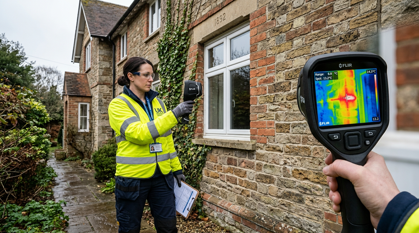
Thermal Imaging: Seeing the Invisible
Of all the technologies available to modern surveyors, thermal imaging cameras have arguably had the greatest impact on what we can find and what we can prove. A thermal imaging camera detects infrared radiation — essentially, it creates a picture of temperature differences across a surface.
In a property survey context, this is incredibly powerful. Damp and moisture in walls appear as cool spots (because water retains heat differently to dry building materials). Missing insulation creates irregular thermal patterns in walls and ceilings. Heat loss through poorly sealed window frames, roof junctions and around pipes becomes immediately visible. Cold bridging — where a structural element creates a pathway for heat loss — is detected instantly.
In one memorable survey of a 1960s bungalow in Pound Hill, the thermal camera revealed that the loft insulation had significantly deteriorated and that there was a large damp patch hidden beneath the plaster on a north-facing wall — neither of which was visible through any other inspection method. The thermal evidence made the defect undeniable to both the buyer and the seller, and informed a successful renegotiation of £12,000 off the purchase price.
When Thermal Imaging Works Best
Thermal imaging is most effective when there is a significant temperature difference between the inside and outside of a property — typically at least 10°C. This makes autumn and winter surveys in West Sussex ideal for thermal imaging analysis. Summer surveys are less definitive, which is one reason we always advise buyers not to delay their survey through the warmer months if they suspect moisture or insulation issues.
Drone Surveys: A New View of Roofs and High-Level Elements
The roof is one of the most critical elements in any building survey — and historically, one of the most difficult to inspect properly. Traditional roof inspections involved ladders, binoculars and a degree of guesswork for pitched roofs that weren't safely accessible. Flat roofs often couldn't be inspected at all without specialist access equipment.
Drone technology has transformed this. A qualified drone pilot-surveyor can now produce high-resolution photography and video footage of every centimetre of a roof — including chimney stacks, roof valleys, lead flashings, ridge tiles, guttering and fascia boards — without setting foot on the roof. The footage is reviewed in real time, can be zoomed and enhanced, and is retained as evidence within the survey report.
For properties in Crawley with complex roof geometries — Victorian terraces with multiple chimney stacks, large commercial-residential buildings, converted loft extensions — drone surveys provide a level of inspection quality that simply wasn't possible before.
It's important to note that drone surveys require the surveyor (or a colleague) to hold a valid CAA drone operator ID and to comply with UK airspace regulations. All drone surveys we conduct are fully compliant with Civil Aviation Authority requirements.
Laser Measuring and 3D Scanning
The humble tape measure has been largely replaced by laser distance measurers for internal floor plan measurements. These devices measure distances to millimetre accuracy in a fraction of the time, allowing surveyors to produce accurate floor plans quickly and document building dimensions that may be relevant to planning assessments, insurance valuations or comparative market analysis.
For more complex assessments — particularly on listed buildings, large commercial properties or historic structures — 3D laser scanning (LiDAR technology) is now being used to create precise three-dimensional models of buildings. These models can be used to detect subtle changes in wall plumb, floor level, or structural geometry that might indicate ongoing movement or settlement.
While full LiDAR scanning isn't standard in residential building surveys, we use laser levels and digital inclinometers to measure floor levels and wall plumb in situations where we suspect movement — giving us accurate data to assess whether any displacement is historic (and therefore stable) or ongoing (and potentially serious).
Advanced Moisture Detection
The moisture meter has been a surveyor's staple for decades, but the technology has evolved significantly. Modern capacitance moisture meters can detect moisture in walls without needing to pierce the plaster — useful for finished properties where the owner doesn't want visible probe holes. They're not as accurate as pin-type meters for quantifying moisture content, but they're invaluable for screening walls quickly and identifying areas that warrant more detailed investigation.
We also use hygrometers to measure relative humidity levels in different rooms, which provides useful context when assessing whether apparent damp is actually condensation caused by a ventilation problem rather than a structural damp ingress issue. This distinction has significant implications for diagnosis and remediation — and for how a survey report is written.
Endoscope Cameras: Seeing Inside Walls and Cavities
Sometimes, the most important evidence about a property's condition is hidden in places that can't be reached without demolition — inside cavity walls, under floor voids, inside chimneys and flues, or within roof spaces that are too narrow to enter safely.
Borescope (endoscope) cameras — essentially flexible cameras on a long probe — allow surveyors to see inside these spaces through a small access hole. We use them to check the condition of wall ties in cavity walls (a critical check in properties built between 1945 and 1990, where certain types of galvanised wall ties are known to corrode), to inspect the interior of flues, and to check under suspended timber floors for signs of wet rot, woodworm or failed supports.
Report Technology: Digital Reports and 3D Floorplans
The survey report itself has also undergone a transformation. Where once you would receive a printed document, today's professional survey reports are digital, interactive and multimedia-rich. Our reports include:
- Colour-coded condition ratings (following the RICS 1-3 traffic light system) for every element of the property
- Embedded photographs of every defect, clearly annotated
- Thermal imaging screenshots linked to specific findings
- Digital floor plans with room measurements
- Repair cost guidance ranges for items requiring attention
- Hyperlinked table of contents for easy navigation
The result is a document that's genuinely useful to the person who commissioned it — not just a formality to satisfy a mortgage lender.
What Technology Cannot Replace
Technology enhances surveying, but it doesn't replace the most important tool in a surveyor's kit: professional experience and local knowledge.
A thermal camera will show me a cold spot on a wall. But it takes fifteen years of surveying properties in Crawley to know whether that cold spot is damp ingress from a failed damp-proof course, a missing insulation batt, or perfectly normal thermal behaviour at a brick reveal. The technology provides the evidence; the surveyor provides the interpretation and the recommendation.
This is particularly true in Crawley, where the housing stock is diverse — from 1930s semi-detached properties in Northgate and Langley Green, to 1960s and 70s system-build houses in Gossops Green and Bewbush, to Victorian terraces in the town centre, to brand-new developments in Forge Wood. Each era of construction has its characteristic defects, and local knowledge is essential for spotting them efficiently.
Should You Ask for a Technology-Enhanced Survey?
If you're purchasing a property in Crawley or the surrounding area, it's worth asking any surveyor you're considering whether they use thermal imaging and drone technology as standard, or whether these are add-ons at additional cost.
At Crawley Surveyors, thermal imaging is included as standard in all our Level 3 Building Surveys, and drone roof surveys are available on request (and recommended for any property where roof access would be difficult or unsafe). We believe these tools produce better surveys and better outcomes for our clients — and the evidence, literally, speaks for itself.
Read more about our full range of surveying services, or learn about what a building survey involves. For specific issues like damp, see our guide to damp in older properties.
Frequently Asked Questions
Does thermal imaging add extra cost to a building survey?
At Crawley Surveyors, thermal imaging is included as standard in Level 3 Building Surveys during the cooler months when temperature differentials make the technology most effective. In warmer months, we still use moisture meters and other methods. Always ask your surveyor what technology is included in their survey fee.
Is a drone roof survey the same as a full roof inspection?
A drone survey is an excellent visual inspection tool and captures much more detail than a surveyor on the ground with binoculars. However, it does not allow the surveyor to physically test the condition of tiles, probe for soft spots or check the underside of the roof covering. For high-risk roof situations, a combination of drone survey and physical access (scaffold or ladders) remains the gold standard.
Can technology replace a physical building survey?
No. There is currently no technology available that can replace a competent surveyor's physical inspection and professional judgement. Technology enhances surveys by detecting things that aren't visible to the naked eye and by documenting conditions more accurately. But the interpretation of findings, and the professional advice that follows, requires human expertise and local knowledge that no instrument can replicate.
Do you carry out desktop surveys or automated valuations?
We do not carry out desktop surveys or automated valuation model (AVM) estimates as standalone services. All our surveys and valuations involve a physical inspection of the property by a qualified surveyor. Desktop assessments — however sophisticated — cannot identify physical defects and should not be used as a substitute for a proper survey when purchasing a property.
Do modern surveys come with photographic evidence?
Yes. All our survey reports include annotated photographs of every significant defect or area of concern. For Level 3 Building Surveys, this typically means 40–80 photographs embedded within the report alongside the relevant sections. Thermal imaging screenshots and drone footage stills are also included where applicable. You'll know exactly what we found and where we found it.